Guanzhong · Prefecture-level city
Xianyang咸阳市
Xianyang spreads along the north bank of the Wei River, with the dry Weibei tablelands to its north. Han and Tang imperial tombs run in a line from west to east across the city's territory.
English summary
This is an English summary. The full entry is in Chinese. Read the full entry in Chinese
At a glance
Xianyang governs 14 county-level divisions: 3 districts, 9 counties and 2 county-level cities.
Together they measure about 10,300 km², 5.0% of the province's measured area, ranking 8 of the ten cities by measured area.
The city runs about 139.2 km east to west and 150.0 km north to south, and its area-weighted centre sits near 34.7831°N · 108.3950°E.
Every figure here is aggregated from the 107 county pages on this site with the same boundary measurements. None of it is taken from an official statistical yearbook.
The divisions
Listed by administrative code — the same order as the Chinese edition. Each name opens its English county page.
- Qindu District District
- Yangling District District
- Weicheng District District
- Sanyuan County County
- Jingyang County County
- Qian County County
- Liquan County County
- Yongshou County County
- Changwu County County
- Xunyi County County
- Chunhua County County
- Wugong County County
- Xingping County-level City
- Binzhou County-level City
Largest by measured area: Xunyi County. Smallest by measured area: Yangling District.
Four seasons
One original illustration drawn four ways, in this city's palette. The vectors open at full size; the raster files are 1280×720 WebP.




These are editorial illustrations, not photographs and not maps: they suggest the season and the landscape, and carry no survey data.
Where it sits
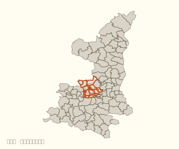
The locator draws all 107 divisions of the province and shades the ones belonging to this city, so the city reads as a piece of the whole rather than as a standalone shape.
Borders inside and outside the city
Under this site's adjacency test, the 14 divisions of this city share 24 borders with one another, and 13 cross-city borders connect them to 5 other cities.
- Borders between divisions
- 24
- Pairs of divisions of this city that share a boundary.
- Neighbouring cities
- 5
- Xi'an, Tongchuan, Baoji, Weinan and Yan'an
- Cross-city borders
- 13
- Borders where the other side belongs to a different city.
Source and confidence
- Names, types and parent city
- Not individually checked
- Area, spans, centre and borders
- Measured
- Summary, seasonal notes, illustrations and palette
- Editorial work
Boundary, area and centre: DataV.GeoAtlas, measured on simplified geometry. Not an official statistic.
Name, type and parent city: DataV.GeoAtlas attributes, not individually checked.
Updated 2026-11-03